Category Archives: History

Dubuque County Aux. – Vol. 4

Time for the final collection of auxiliary images I took while harvesting the town signs of Dubuque County.

The first few images in the collection are from the New Melleray Abbey. It is a monastery of Trappist Monks that supports themselves by making coffins. Yes. Coffins.

Here is some information about them from their website (newmelleray.org):

New Melleray is a community of Roman Catholic monks. We belong to the Order of Cistercians of the Strict Observance, commonly known as Trappists. Disciples of Jesus Christ, we join countless men and women who throughout fifteen hundred years have discovered the Rule of Saint Benedict to offer a challenging and effective way of living the Gospel. Our communal way of monastic life in the Cistercian tradition serves our desire to be wholly oriented to the experience of the living God.

Located southwest of Dubuque, Iowa, New Melleray was founded in 1849 by monks of our Order from Mount Melleray Abbey, Ireland. Like all monasteries, New Melleray Abbey is a school of charity. The monastery is a place where we learn to love God, to love ourselves, and to love each other. Together with its fertile farmland and rugged woodlands our monastery provides us with solitude and precious silence.

Through our guest house and other forms of monastic hospitality, we are happy to offer to our brothers and sisters who follow other paths, a place where they may find acceptance, peace, and prayer. Click on “Visit Us” for various ways to share in our way of life as a long-term guest living within the community.

With Trappist Caskets we support ourselves and supply employment to local men and women by making and selling simple wooden caskets and burial urns of exceptional quality.

I do want to go back and check it out when I have more time, so if you are interested in such a road trip, let me know. I don’t think I’ll get many takers on that one.

Here are the pictures:


Dubuque County  - New Melleray Abbey
New Melleray Abbey

Dubuque County  - New Melleray Abbey

Dubuque County  - New Melleray Abbey

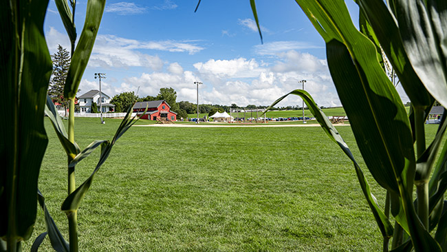
Dubuque County  - Field of Dreams
Field of Dreams

Dubuque County  - Field of Dreams

Dubuque County  - Field of Dreams
A hot dog stuck in her throat…

Dubuque County  - Field of Dreams

Dubuque County  - Field of Dreams
They were serious. They had a guard watching people.

Dubuque County  - Field of Dreams

Dubuque County  - Field of Dreams

Dubuque County  - Field of Dreams
Seriously? They can’t bury those power lines?

Dubuque County  - Field of Dreams
That is the corn guard. In the background is the lights of the Major League stadium where the Cubs and Reds played and the White Sox and Yankees the year before that.

Dubuque County  - Field of Dreams

Dubuque County  - Field of Dreams
The corn guard actually did try to rustle me out of the corn.

Dubuque County  - Field of Dreams

Dubuque County  - Field of Dreams

Dubuque County  - Field of Dreams

Dubuque County  - Field of Dreams

Dubuque County  - Field of Dreams

Dubuque County  - Field of Dreams

Dubuque County  - Field of Dreams

Dubuque County  - Field of Dreams

Dubuque County  - Field of Dreams

Dubuque County  - Field of Dreams

Dubuque County  - Field of Dreams

Dubuque County  - Field of Dreams

Dubuque County  - Field of Dreams

Dubuque County  - Field of Dreams

Dubuque County  - Field of Dreams

Dubuque County  - Field of Dreams

Dubuque County  - Field of Dreams

Dubuque County  - Field of Dreams

This might make me a bad Iowan, but I actually don’t love the movie FIELD OF DREAMS. That being said, the field from the movie still being around is pretty sweet and it is definitely worth a visit. Bring a ball and a glove and “play catch”. Only psychos “have a catch”.

Would you believe that there are only 2 counties worth of auxiliary images left to share? Well, believe it because it is true. Next up is Scott County.

Rodan139: Kate Shelley Museum

I recently took Rodan139 down for a quick flight around the grounds of the Kate Shelley Museum. I should really take Rodan139 every day while it is still illegal to fly. Rodan139 is a DJI Mavic Pro2. On September 16, it will be illegal to fly the guy without adding a Remote ID Module. Now there is a rumor out there that the Remote ID module might get postponed. I’m hoping this happens because the Remote ID Module is not module. The average price of them is around $250. Which isn’t a terrible price to keep Rodan139 in the sky, but the other side of the coin is that many of them are on backorder. Even if I wanted to get one, I don’t know than I could.

Anyways, here is hoping that the new rule gets postponed. And here are some pictures of the Kate Shelley Museuum:


Rodan139: Kate Shelley Museum

Rodan139: Kate Shelley Museum

Rodan139: Kate Shelley Museum

Rodan139: Kate Shelley Museum

Rodan139: Kate Shelley Museum

Rodan139: Kate Shelley Museum

Rodan139: Kate Shelley Museum

Rodan139: Kate Shelley Museum

Rodan139: Kate Shelley Museum

Rodan139: Kate Shelley Museum

Rodan139: Kate Shelley Museum

Rodan139: Kate Shelley Museum

Rodan139: Kate Shelley Museum

Rodan139: Kate Shelley Museum

Rodan139: Kate Shelley Museum

Rodan139: Kate Shelley Museum

Hopefully there is another collection of drone pictures next Tuesday.

Dubuque County Aux. – Vol. 3

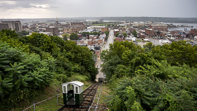
Time once again to share some auxiliary images I took while harvesting the town signs of Dubuque County. Last time we left off I was sharing pictures from the Fenelon Place Elevator. Here is some more information on the “world’s shortest and steepest railway” (https://www.fenelonplaceelevator.com/):

Fenelon Place Elevator Company
512 Fenelon Place
Dubuque, Iowa 52001

Historic cable car. Also known as the Fourth Street Elevator, this funicular railway has been called “the world’s steepest, shortest scenic railway.” 296 feet in length, elevating passengers 189 feed from Fourth Street up to Fenelon Place. Magnificent view of downtown Dubuque business district, the Mississippi River and three states. Buses should go to the bottom of the bluff. Please use 4th and Bluff Streets for GPS. Narrow streets with parking on both sides at the top of the bluff. Open 8 AM to 10 PM daily April 1 though November 30. Closed Thanksgiving. We do not accept debit or credit cards.

And from the history section of their website:

In 1882, Dubuque was an hour and a half town – at noon everything shut down for an hour and a half when everyone went home to dinner.

Mr. J. K. Graves, a former mayor, former State Senator, also promoter of mines and a banker lived on top of the bluffs and worked at the bottom. Unfortunately, he had to spend half an hour driving his horse and buggy round the bluff to get to the top and another half an hour to return downtown, even though his bank was only two and a half blocks away.

Mr. Graves liked to take half an hour for his dinner, then a half an hour nap, but this was im-possible because of the long buggy ride.

As a traveler he had seen incline railways in Europe and decided that a cable car would solve his problem. He petitioned the city for the right to build. The franchise was granted on June 5, 1882.

John Bell, a local engineer, was hired to design and to build a one-car cable modeled after those in the Alps.

The original cable car, which was built for Mr. Graves’ private use, had a plain wood building, that housed a coal-fired steam engine boiler and winch. A wooden Swiss-style car was hauled up and down on two rails by a hemp rope.

Mr. Graves’ cable car operated for the first time on July 25, 1882. After that, he had his gardener let him down in the morning, bring him up at noon, down after dinner and nap, and up again at the end of the work day. Before long, the neighbors began meeting him at the elevator asking for rides.

On July 19, 1884, the elevator burned when the fire that was banked in the stove for the night was blown alive. After Mr. Graves rebuilt the elevator, he remembered how his neighbors showed up when he used the cable car and he decided to open it to the public. He charged five cents a ride.

The elevator burned again in 1893. Because there was a recession Mr. Graves could not afford to rebuild the cable car. The neighbors had come to depend on the elevator to get them to work, to church, to school, and to the market.

Ten neighbors banded together and formed the Fenelon Place Elevator co. Mr. Graves gave them the franchise for the right of way for the track. This group traveled to the 1893 Colombian Exposition in Chicago, Illinois, to look for new ideas. They brought back a streetcar motor to run the elevator, the turnstile, and steel cable for the cars. They had remembered that each time the elevator house burned, the fire also burned through the hemp rope that held the car and sent it crashing down the hill destroying it and the little house at the bottom. Then they in-stalled three rails with a fourth bypass in the middle to allow for the operation of two (funicular) counterbalanced cars.

By 1912, C. B. Trewin, who had built a house next door in 1897, became the sole stockholder. It was natural for him to buy up the stock from the original ten stockholders as they either passed away or moved away.

Mr. Trewin added garages to the north and south sides of the operator’s house in 1916. He also added a second floor apartment which the neighborhood men used for a meeting room where they could smoke and play cards without the wives interfering.

The auxiliary images:


Dubuque County  - Dubuque
Fenelon Place Elevator

Dubuque County  - Dubuque

Dubuque County  - Dubuque

Dubuque County  - Dubuque

Dubuque County  - Dubuque

Dubuque County  - Dubuque

Dubuque County  - Dubuque

Dubuque County  - Dubuque

Dubuque County  - Dubuque

Dubuque County  - Dubuque

Dubuque County  - Dubuque

Dubuque County  - Dubuque

Dubuque County  - Dubuque

Dubuque County  - Dubuque

Dubuque County  - Dubuque

Dubuque County  - Dubuque

Dubuque County  - Dubuque

Dubuque County  - Dubuque

Dubuque County  - Dubuque

Dubuque County  - Dubuque

Dubuque County  - Dubuque

Dubuque County  - Dubuque

Dubuque County  - Dubuque

Dubuque County  - Dubuque

Dubuque County  - Dubuque

Dubuque County  - Dubuque

Dubuque County  - Peosta
Peosta

Dubuque County  - New Melleray Abbey
New Melleray Abbey

Dubuque County  - New Melleray Abbey

Dubuque County  - New Melleray Abbey

There is only one collection in this post of the many amazing murals in Dubuque. I actually did a little more research into the murals of Dubuque and they are a lot more extensive than I thought. I will definitely be going back to Dubuque at some point to photograph as many of them as possible!

There is still one more collection of images from Dubuque County left to share!

Des Moines & Louisa County Aux. – Vol. 5

This is the final collection of images I took while harvesting the town signs of Des Moines & Louisa County. I really found Burlington to be photogenic and would like to go back there and spend some time photographing it. Also, and not unrelated, there is a stop on the Tenderloin Trail 2.0 that could be incorporated into any trip of the sort.

Last time we left off on Snake Alley in Burlington:


Des Moines County - Burlington

Des Moines County - Burlington

Des Moines County - Burlington

Des Moines County - Burlington

Des Moines County - Burlington

Des Moines County - Burlington

Des Moines County - Burlington

Des Moines County - Burlington
The less famous but still fascinating Cobblestone Alley.

Des Moines County - Burlington

Des Moines County - Burlington

Des Moines County  -
Illinois

Des Moines County  - Middletown
Middletown – The site of a giant ammunition plant that I had no clue existed.

Des Moines County  -
A resident of Danville was a pen pal of Anne Frank.

Des Moines County

Des Moines County

Des Moines County

Des Moines County

Des Moines County

Louisa County - Cairo
Cairo

Louisa County - Cairo

Louisa County - Cairo

Louisa County

Louisa County - Wyman
Wyman

Washington County - Ainsworth
A meal from the Dairy Mart in Ainsworth.

Marshall County - Quarry

Marshall County - Quarry

Marshall County - Quarry
I want one.

Marshall County - Quarry
Quarry

Marshall County - Quarry

Marshall County - Quarry

I think we need to dive into the history of a couple things. Starting with Snake Alley.

From the Wiki:

The physical limitations and steep elevation of Heritage Hill inspired the construction of Snake Alley in 1894. It was intended to link the downtown business district and the neighborhood shopping area located on North Sixth Street, of which Snake Alley is a one-block section. Three German immigrants conceived and carried out the idea of a winding hillside street, similar to vineyard paths in France and Germany: Charles Starker, an architect and landscape engineer; William Steyh, the city engineer; and George Kriechbaum, a paving contractor. The street was completed in 1898, but was not originally named Snake Alley, as it was considered part of North Sixth Street; some years later, a resident noted that it reminded him of a snake winding its way down the hill, and the name stuck.

The alley originally provided a shortcut from Heritage Hill to the business district. Bricks were laid at an angle to allow horses better footing as they descended. Unfortunately, riding horses back up the alley often resulted in a loss of control at the top; for this reason, even to this day, Snake Alley remains a one-way street, with all traffic heading downhill.

And about that connection with Anne Frank. From the Danville Library website:

Our story goes back to the fall of 1939 when a Danville teacher, Miss Birdie Mathews, initiated a pen pal exchange for her class. Ten year old Juanita Wagner picked a name from a list of pen pals. She chose a girl her own age who lived in Amsterdam. The girl’s name was Anne Frank.
Danville, Iowa is one of two places in the world to view the pen pal letters. These letters are on display at the Danville Museum.

The things you had no clue were in Iowa!!

The next set of auxiliary images will come from a rain day I spent in Dubuque County.

Des Moines & Louisa County Aux. – Vol. 3

Today is Russell’s birthday, so I need to wish Russell a happy birthday, so happy birthday Russell!


Civil Rights Museum

I’m not sure I’ve seen Russell in person since before the pandemic. That seems like something that should be remedied. Either way, I hope your birthday is filled with all the joy you can handle.

+++++++

Time to continue with the auxiliary images from my trip to Des Moines County and Louisa County to harvest their town signs. Last time we left off, we were in Grnadview. After that, I took US-61 down to Wapello.


Louisa County

Louisa County - Wapello
Wapello

Louisa County - Wapello

Louisa County - Wapello

Louisa County - Wapello

Louisa County - Wapello

Louisa County - Wapello

Louisa County - Wapello

Louisa County - Wapello

Louisa County - Toolesboro
Toolesboro

Louisa County - Toolesboro

Louisa County - Toolesboro

Louisa County - Toolesboro

Louisa County - Toolesboro

Louisa County - Toolesboro

Louisa County - Oakville
Oakville

Louisa County

Louisa County

Louisa County

Louisa County - Morning Sun
Morning Sun

Louisa County - Morning Sun

Louisa County - Morning Sun

Louisa County - Morning Sun

Louisa County - Morning Sun

Louisa County - Morning Sun

Louisa County - Morning Sun

Louisa County

Louisa County

Louisa County

So we should probably discuss some of the history in some of these pictures.

Here is some information on the Toolesboro Mounds:

The Toolesboro site consists of seven burial mounds on a bluff overlooking the Iowa River near where it joins the Mississippi River. The conical mounds were constructed between 200 B.C. and 300 A.D. by a local Hopewell group. They include some of the best-preserved and accessible remnants of Iowa’s Hopewell culture, a Middle Woodland people who hunted, gathered and gardened. At one time, there may have been as many as twelve mounds, but subsequent settlement and excavation have reduced that number to the present seven. As of yet, no village site near the Toolesboro mounds has been located, which is attributed to the shifting path of the Iowa River which has obliterated possible village sites on the flood plain over the last 2,000 years.

Of the seven mounds, only two are visible on the grounds of the Educational Center. The rest are off in the woods, and are separated by a wire fence from the Educational Center. One of the mounds maintained near the center, known as Mound 2, is the largest of the remaining mounds, measuring 100 feet in diameter and eight feet in height. This mound was possibly the largest Hopewell mound in Iowa.

And the Littleton Brothers… well…

The largest loss of life known in the history of all U.S. wars from any immediate family were the six local Littleton Brothers. All six were lost to the Civil War and the story just recently discovered and documented.

Here is some information on the Littleton brothers from the website (http://civil-war-picket.blogspot.com/):

James and Martha Littleton, the boys’ parents, moved to Louisa (Lew-I-zuh) County in about 1840, six years before Iowa became a state. The young Littleton brothers likely helped on a 200-acre farm.

Toolesboro used to be a busy hub, said Wagner, who lives in Illinois City, Ill.

The 1860 census that shows the family was listed as mulatto, which traditionally refers to a person with one white parent and one black parent. There’s debate today on that point.

The Littleton memorial will have a panel saying James came from free slave roots. “Records indicate Louisa County abolitionists had helped the family get settled there.”

But oral history within the Nicewanner family, as descendants of Permelia, states that James actually had Native American roots on one side, said Wagner.

Doug Jones, an archaeologist and Iowa Freedom Trail project manager for the State Historical Society of Iowa, said the little information he has on the Littletons is “quite intriguing.”

“There was a mulatto settlement, and we don’t know much about the settlement.”

Only one of the Littleton brothers, John, had children, and that daughter died before having any of her own. James and Martha Littleton died before the war.

Here’s what is known about each of the brothers’ service records (thanks to the Iowa Gold Star Military Museum for much of the following information):

— George Handy Littleton: George, 33, a cooper, volunteered from service from nearby New Boston, Ill., in March 1862. He is described as having brown eyes and dark hair and complexion. He was with Company B of the 65th Illinois Infantry. Captured by Confederates at Harpers Ferry, W.V., he was later paroled and discharged for disability in Chicago, according to official records, for a disease contracted before service. Woodruff said other material indicates Littleton got sick while in service. “We do not have the exact date or know where we died,” said Woodruff. The Columbus Gazette indicated George died soon after returning home. His grave has not been found.

— John Littleton: Enlisted in August 1862 with Company F of the 19th Iowa Volunteer Infantry. He suffered a severe thigh injury during fighting at Prairie Grove, Arkansas, on Dec. 7, 1862. He died in Fayetteville, Ark., of wounds on December 18. It’s possible he may be buried among 800 unmarked graves at Fayetteville National Cemetery.

— Kendall Littleton: Also of the 19th Iowa, Kendall was killed in action on Dec. 7, 1862, at Prairie Grove, Ark. His remains were likely later moved to Fayetteville National Cemetery, and are marked as unknown.

— Noah Littleton: Survived the fighting at Prairie Grove but drowned March 1, 1863, in the White River in southern Missouri. His remains were disinterred and he is buried at Springfield (Mo.) National Cemetery. He, too, served in the 19th Iowa.

–Thomas Littleton: A member of the 5th Iowa, suffered a head wound at Iuka, Ms. He was taken prisoner in Chattanooga, Tenn., in November 1863. The private died of chronic diarrhea at Andersonville on June 16, 1864, and is buried at the national cemetery there.

— William Littleton: A corporal with the 8th Iowa, William was wounded at Shiloh in 1862 and died in December 1863 of diarrhea at Jefferson Barracks, Mo. He is buried at the national cemetery there.

There is still plenty more pictures left to share from this trip!

Des Moines & Louisa County Aux. – Vol. 2

Just a reminder that the deadline for the Pufferbilly Days Photo Contest is coming up, but there is still time to enter:


Thanks to Monica for making the sweet graphic for social media posts!

++++++

For rules and the entry form, go here:

Time to share a second collection of images from my trip to Des Moines County and Louisa County to harvest their town signs. We start still in Columbus Junction.


Louisa County - Columbus Junction
Columbus Junction

Louisa County - Columbus Junction

Louisa County - Columbus Junction

Louisa County - Columbus Junction

Louisa County - Columbus Junction

Louisa County - Columbus Junction

Louisa County - Columbus Junction

Louisa County - Columbus Junction

Louisa County - Columbus Junction

Louisa County - Fredonia
Fredonia

Louisa County - Fredonia

Louisa County - Fredonia

Louisa County - Fredonia

Louisa County - Fredonia

Louisa County - Fredonia

Louisa County - Fredonia

Louisa County - Columbus Junction
Back in Columbus Junction

Louisa County - Columbus Junction

Louisa County - Columbus Junction

Louisa County - Grandview
Grandview – Full applause for this sign.

Louisa County - Grandview

Louisa County - Grandview

Louisa County - Grandview

Louisa County - Grandview

Louisa County - Grandview

Louisa County - Grandview

Louisa County - Grandview

Louisa County - Grandview

Louisa County - Grandview

Louisa County - Grandview

A few notes about the Convict Road. The first section of concrete road in Iowa was placed in Le Mars in 1904. It was in service until 1968 when it was replaced. The oldest concrete road in Iowa that is still in service in Iowa is The Eddyville Cemetery Road. It was place in 1909. The Convict Road in Fredonia may be the 2nd oldest concrete paved road in Iowa. However, a segment of the Moscow Road might be older. It was placed in 1910. I’m not sure if it still exists. The history of concrete roads in Iowa isn’t as exciting as you might think so many sources seem to be out of date. Which is truly a shame. Most of it seems to link to a report by a Todd D. Hanson that was made in March of 2009.

The first rural paving in Iowa was between Mason City and Clear Lake. This happened in 1915.

The oldest concrete street in America is in Bellefontaine, Ohio. They paved Court Avenue in 1891 and one block of it remains the original concrete.

There is a lot more from my trip to these two counties left to share. But this is all I have on old concrete roads in Iowa.

Des Moines & Louisa County Aux. – Vol. 1

Tuesday has traditionally been the day I share images from Rodan139, but frankly I’m currently out of Rodan139 photos to share. I’m not sure when I’ll be able to take some more. My schedule this week with both work and getting free 3-D sculpted Iowa State artwork and hopefully trying some of Scottie D.’s new butcher paper brisket and the Boone County Fair and work party and little kid party and Movie Night is pretty dang full.

Ahhh… the Boone County Fair… this reminds me that I have yet to make an official announcement about Baby Got Rack. Baby Got Rack is taking the year off from competitive barbecue.

I know… I know… it is very sad. However, there is reason for hope. What I’m going to call Baby Got Rack: The Next Generation will be competing at the Boone County Fair’s barbecue competition this year. I thought about going with Baby Got Rack Jr., actually I’m workshopping both. I’ll let you know when I have decided which one I like better.

But back to the Boone County barbecue competition. While Scottie D. won’t be out their slinging ribs and pizza and the loins, his eldest progeny Austin will be entering the youth competition. He had a practice run at the porkloin on Sunday night and Scottie D. says that he nailed it!

My nephew Logan is also competing on Saturday as well. Logan (I don’t think I’m giving away any secrets) is competing in Pork and Turkey. He has practiced with 5 or 6 different recipes for his ribs alone. He also had a practice run on Sunday and while he wasn’t satisfied, I bet they were probably pretty dang delicious.

I’ll be out there at different times of the day helping both parties with anything they need. So while Baby Got Rack won’t be out there slinging that good meat, the next generation will and you should still come out and support them.

Have no fear, even if Baby Got Rack has retired for good, the barbecue community in Boone County is still in good hands.

Also, I will be out there as I am judging the Boone County Fair Photography Contest. It will be a full day!

(Also: Baby Got Rock Founding Father Scottie D. is in charge of the Pufferbilly Days Barbecue Contest this year. It is like we are slowly taking over the world. BGR 4 Life!)

+++++++

Since I don’t have any drone pictures to share, I thought I would start sharing auxiliary images I took while harvesting the town signs of Des Moines County and Louisa County. Both counties have some very interesting things in them. Some things I knew about and some things I did not know about.


Iowa County
Iowa County

Iowa County

Louisa County
Louisa County

Louisa County - Cotter
Cotter

Louisa County - Cotter

Louisa County - Cotter

Louisa County - Columbus City
Columbus City

Louisa County - Columbus City

Louisa County - Columbus Junction
Columbus Junction

Louisa County - Columbus Junction

Louisa County - Columbus Junction

Louisa County - Columbus Junction

Louisa County - Columbus Junction

Louisa County - Columbus Junction

Louisa County - Columbus Junction

Louisa County - Columbus Junction

Louisa County - Columbus Junction

Louisa County - Columbus Junction
I would love to see a picture of this original bridge.

Louisa County - Columbus Junction

Louisa County - Columbus Junction

Louisa County - Columbus Junction
Love. Ain’t it grand?

Louisa County - Columbus Junction

Louisa County - Columbus Junction

Louisa County - Columbus Junction

Louisa County - Columbus Junction

Louisa County - Columbus Junction

Louisa County - Columbus Junction

Louisa County - Columbus Junction

Louisa County - Columbus Junction

Louisa County - Columbus Junction

When I complete editing and sharing all of the auxiliary images from THE TOWN SIGN PROJECT, I will put together an Iowa Bridge Power Rankings. I mean it is pretty obvious what is #1, but there is a pretty stiff battle for #2. The Columbus Junction Swinging Bridge is definitely in the mix for a good ranking!

Lee & Van Buren County Aux. – Vol. 4

Time to share another collection of images from my road trip to Lee County & Van Buren County to harvest their town signs. All of these pictures are taken in Van Buren County. In the villages of Bonaparte and Bentonsport.


Van Buren County - Bonaparte
Bonaparte

Van Buren County - Bonaparte

Van Buren County - Bonaparte

Van Buren County - Bonaparte

Van Buren County - Bonaparte

Van Buren County - Bonaparte

Van Buren County - Bonaparte

Van Buren County - Bonaparte

Van Buren County - Bonaparte

Van Buren County - Bonaparte

Van Buren County - Bonaparte

Van Buren County - Bonaparte

Van Buren County - Bonaparte

Van Buren County - Bonaparte

Van Buren County - Bentonsport
Bentonsport

Van Buren County - Bentonsport

Van Buren County - Bentonsport

Van Buren County - Bentonsport

Van Buren County - Bentonsport

Van Buren County - Bentonsport

Van Buren County - Bentonsport

Van Buren County - Bentonsport

Van Buren County - Bentonsport

Van Buren County - Bentonsport

Van Buren County - Bentonsport

Van Buren County - Bentonsport

Van Buren County - Bentonsport

Van Buren County - Bentonsport

Van Buren County - Bentonsport

Van Buren County - Bentonsport

Van Buren County - Bentonsport

Van Buren County - Bentonsport

Van Buren County - Bentonsport

Van Buren County - Bentonsport

Van Buren County - Bentonsport

So let’s talk a moment about The Mason House Inn. It has had an absolutely fascinating history. From their website (masonhouseinn.com):

The Mason House Inn was built in 1846, originally called the Ashland House, and was owned by William Robinson. It was built as a hotel to serve the steamboat travelers going from St. Louis to Fort Des Moines and Fort Dodge on the Des Moines River. It was built by Mormon craftsmen from Nauvoo, Illinois, who stayed in Bentonsport for several years, working and gathering supplies before making their trek westward to Salt Lake City, Utah. (Several of the brick buildings still in use here in Bentonsport were built by these craftsmen.) In 1857, the Ashland House was purchased by Lewis Mason and his wife, Nancy. They changed the name to the Phoenix Hotel, but the townspeople called the place the “Mason’s House”, and the name stayed. It was Nancy who started the tradition of “a cookie jar in every room”.

Over the years, the Mason House has withstood 6 major floods: 1851, 1903, 1905, 1947 and, most recently, 1993 and 2008. Through it all, this magnificent building remains a stalwart landmark. During the Civil War, the Mason House was used as a “holding hospital” for the wounded soldiers who were waiting for the train or boats to take them to the hospital in Keokuk. It was also a station on the Underground Railroad. For a short time in 1913 the building was used as a tuberculosis sanitarium. But the building was too small for their needs and they moved to Des Moines. From 1920 to 1950, Lewis’ grand-daughter, Fannie Mason Kurtz, ran the hotel as a boarding house for the town doctor and his wife and also the local school teachers. When Fannie died in 1951, the place was rented as a house for the Downing family until 1956.

Here is a little more. Remember last Wednesday when we talked about the Mormons being ran out of Nauvoo, Illinois? They settled in Van Buren County for a time and some built the Mason Inn.

The Mason Inn is considered haunted and for this reason, they ban guns inside of the Inn:

DO NOT BRING ANY GUNS OR FIREARMS OF ANY KIND INTO THE INN! I don’t care if you have a conceal carry permit or not. This is our house. Our rules. Its not that we are anti-gun (we actually have a rifle at our farm) but the ghosts don’t like guns and 2 of the ghosts know how to pull the trigger. One guest brought a hand gun without us knowing. He placed it on the night stand next to his bed. In the morning he found the gun on the dresser, pointed at his head. The clip was out of the gun and on a different dresser across the room. There was still a bullet in the chamber. If the ghosts could do that, they could have just as easily pulled the trigger. This is a true story.

I would love to stay there sometime. Maybe I’ll put it on my list for next year.

There is still one more collection of images to share from this road trip!

Lee & Van Buren County Aux. – Vol. 3

Time for another collection of images I took while harvesting the town signs of Lee County and Van Buren County. This collection begins in Lee County and then ends in Van Buren County.


Lee County  - Montrolse
This reminds me, who wants to hit up Stanhope Watermelon Day with me? July 15!

Lee County  - Keokuk
Keokuk

Lee County  - Keokuk

Lee County  - Keokuk

Lee County  - Keokuk

Lee County  - Keokuk

Lee County  - Keokuk
I need to go back and get a way better picture of the Keokuk Plant.

Lee County  - Keokuk

Lee County  - Keokuk

Lee County  - Keokuk

Lee County  - Keokuk

Lee County  - Keokuk

Lee County  - Keokuk

Lee County  - Keokuk

Lee County  - Keokuk

Lee County  - Keokuk

Lee County  - Keokuk

Lee County  - Keokuk
Donnellson

Lee County  - Keokuk

Lee County

Lee County

Van Buren County - Farmington
Farmington

Van Buren County - Farmington

Van Buren County - Farmington

Van Buren County - Farmington

Van Buren County - Farmington

Van Buren County - Farmington
I wish I would have went inside Hel-Mart.

Van Buren County - Farmington

Van Buren County - Farmington

Van Buren County - Bonaparte
Bonaparte

Van Buren County - Bonaparte

Van Buren County - Bonaparte

Van Buren County - Bonaparte

Van Buren County - Bonaparte

I definitely want to go back and spend more time in Keokuk and photograph it better. Also Bonaparte. Actually most of the villages of Van Buren. I wonder if there is an inn in Van Buren County that is haunted with gun hating ghosts…

Lee & Van Buren County Aux. – Vol. 2

Time for another collection of images from my road trip to Lee County and Van Buren County to harvest their town signs. All of these pictures are taken in Lee County.


Lee County - West Point
West Point

Lee County - West Point
West Point has a badass window painter.

Lee County - West Point

Lee County - West Point

Lee County - West Point

Lee County - West Point
So I think this is badass. There are scores of towns across Iowa that has their own mini Statue of Liberty. I’m pretty sure I’ve seen every single one of them. This is the ONLY one that has a base that is a replica of the base that the actual Statue of Liberty sits on. When I sent a picture of it to a bunch of people I didn’t even get a single response. Not a SINGLE person was impressed by this and this makes me sad. Melancholy even.

Lee County - West Point

Lee County - West Point

Lee County - West Point
I like to hit a bakery on these trips if I can.

Lee County - West Point

Lee County - West Point

Lee County - Fort Madison
Fort Madison

Lee County - Fort Madison

Lee County - Fort Madison
Lee County has 2 courthouses.

Lee County - Fort Madison

Lee County - Denmark
Denmark

Lee County - Denmark

Lee County - Denmark
I bet this place was the bomb in the day!

Lee County - Denmark

Lee County  - Denmark

Lee County - Montrose
Montrose

Lee County - Montrose
If you look closely here you can see a giant white building across the Mississippi River. That is a rebuilt LDS Temple in Nauvoo, Illinois. More on that later.

Lee County - Montrose

Lee County - Montrose

Lee County - Montrose

Lee County - Montrose

Lee County - Montrose

Lee County - Montrose

Lee County - Montrose

Lee County - Montrose

Lee County - Montrose

Lee County - Montrose

Lee County - Montrose

Lee County - Montrose

Lee County - Montrose

Here is a little history of Nauvoo and the LDS Temple there from the Wiki:

In late 1839, arriving Latter Day Saints bought the small town and in April 1840 it was renamed Nauvoo by Joseph Smith, who led the Latter Day Saints to Nauvoo to escape conflict with the state government in Missouri. The name Nauvoo is derived from the traditional Hebrew language with an anglicized spelling. The word comes from Isaiah 52:7, “How beautiful upon the mountains…” By 1844 “Nauvoo’s population had swollen to 12,000, rivaling the size of Chicago” at the time.

After Joseph Smith’s death in 1844, continued violence from surrounding non-LDS members forced most Latter-Day Saints to leave Nauvoo. Most of these followers, led by Brigham Young, emigrated to the Great Salt Lake Valley. In 1849, Icarians moved to the Nauvoo area to implement a utopian socialist commune based on the ideals of French philosopher Étienne Cabet. The colony had nearly 500 members at its peak, but Cabet’s death in 1856 led some members to leave this parent colony.

The Icarians are the same cult that setup shop in Corning, Iowa. The remains of their cult compound still remain today.

More:

The Latter Day Saints made preparations to build a temple soon after establishing their headquarters at Nauvoo, Illinois, in 1839. On April 6, 1841, the temple’s cornerstone was laid under the direction of Joseph Smith, the church founder and president; Sidney Rigdon gave the principal oration. At its base the building was 128 feet (39 m) long and 88 feet (27 m) wide with a clock tower and weather vane reaching to a total height of 165 feet (50 m)—a 60% increase over the dimensions of the Kirtland Temple. Like Kirtland, the Nauvoo Temple contained two assembly halls, one on the first floor and one on the second, called the lower and upper courts. Both had classrooms and offices in the attic. Unlike Kirtland, the Nauvoo Temple had a full basement which housed a baptismal font. Because the Saints had to abandon Nauvoo, the building was not entirely completed. The basement with its font was finished, as were the first floor assembly hall and the attic. When these parts of the building were completed they were used for performing ordinances (basement and attic) or for worship services (first floor assembly hall).

A Sunstone from the original Nauvoo Temple in a case in front of LDS Church’s Visitor Center in Nauvoo
The Nauvoo Temple was designed in the Greek Revival style by architect William Weeks, under the direction of Joseph Smith. Weeks’s design made use of distinctively Latter Day Saint motifs, including sunstones, moonstones, and starstones. It is often mistakenly thought that these stones represent the three degrees of glory in the Latter Day Saint conception of the afterlife, but the stones appear in the wrong order. Instead, Wandle Mace, foreman for the framework of the Nauvoo Temple, has explained that the design of the temple was meant to be “a representation of the Church, the Bride, the Lamb’s wife”.[4] In this regard, Mace references John’s statement in Revelation 12:1 concerning the “woman clothed with the sun, and the moon under her feet, and upon her head a crown of twelve stars.” This explains why the starstones are at the top of the temple (“crown of twelve stars”), the sunstones in the middle (“clothed with the sun”) and the moonstones at the bottom (“moon under her feet”).

Construction was only half complete at the death of Joseph Smith in 1844. After a succession crisis, Brigham Young was sustained as the church’s leader by the majority of Latter Day Saints in Nauvoo. As mob violence increased during the summer of 1845, he encouraged the Latter Day Saints to complete the temple even as they prepared to abandon the city, so portions of it could be used for Latter Day Saint ordinance, such as baptisms for the dead in the basement font. During the winter of 1845–46, the temple began to be used for additional ordinances, including the Nauvoo-era endowment, sealings in marriage, and adoptions. The Nauvoo Temple was in use for less than three months.

Most of the Latter Day Saints left Nauvoo, beginning in February 1846, but a small crew remained to finish the temple’s first floor, so that it could be formally dedicated. Once the first floor was finished with pulpits and benches, the building was finally dedicated in private services on April 30, 1846, and in public services on 1 May. In September 1846 the remaining Latter Day Saints were driven from the city and vigilantes from the neighboring region, including Carthage, Illinois, entered the near-empty city and vandalized the temple.

Initially the church’s agents tried to lease the structure, first to the Catholic Church, and then to private individuals. When this failed, they attempted to sell the temple, asking up to $200,000, but this effort also met with no success. On March 11, 1848, the LDS Church’s agents sold the building to David T. LeBaron, for $5,000. Finally, the New York Home Missionary Society expressed interest in leasing the building as a school, but around midnight on October 8–9, 1848, the temple was set on fire by an unknown arsonist. Nauvoo’s residents attempted to put out the fire, but the temple was gutted. James J. Strang, leader of the Strangite faction of Latter Day Saints, accused Young’s agents of setting fire to the temple. However, Strang’s charges were never proven. On April 2, 1849, LeBaron sold the damaged temple to Étienne Cabet for $2,000. Cabet, whose followers were called Icarians, hoped to establish Nauvoo as a communistic utopia.[5]

From 1937 to 1962, the LDS Church reacquired and restored the lot on which the temple stood.[8] The church bought the portion that initially housed the temple in an uncontested public auction on February 19, 1937, for $900, after previously being listed and protected by the bank at auction several times because prices were lower than expected.[8] Wilford C. Wood then bought the majority of the remainder of the temple square in 1940, 1941, and 1951 and transferred it to Corporation of the Presiding Bishop of the Church of Jesus Christ of Latter Day Saints.[8] The Corporation bought the remainder of the property with purchases in 1959, 1961 and 1962.[8]

In 1999, church president Gordon B. Hinckley announced the rebuilding of the temple on its original footprint. After two years of construction, on June 27, 2002, the church dedicated the Nauvoo Illinois Temple, whose exterior is a replica of the first temple, but whose interior is laid out like a modern LDS temple.

Anyways, I find it fascinating as I like history, religion, and religious history. Mormon history is also fascinating.

There is even more that happened in Nauvoo with Joseph Smith III and the establishment of the Reorganized Church of Jesus Christ of Later Day Saints, which is now called The Community of Christ, but this is probably enough history for today.